746 items
Laurent SALOMON / Naturimages

10LSL00361
Aerial photo of the island at Point Saint Armel in the Gulf of Morbihan [AT]

10LSL00360
Aerial photo of the pond in the Peninsula Ludre Rhuys [AT]
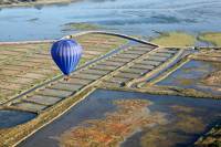
10LSL00359
Aerial photo of a hot air balloon above the Gulf of Morbihan [AT]

10LSL00358
Aerial photo of a hot air balloon above the Gulf of Morbihan [AT]

10LSL00357
Aerial photo of a hot air balloon above the Gulf of Morbihan [AT]

10LSL00356
Aerial photo of a hot air balloon above the Gulf of Morbihan [AT]

10LSL00355
Aerial photo of Dumnacus bridge over the Loire Ponts de Cé [AT]

10LSL00354
Aerial photo of Dumnacus bridge over the Loire Ponts de Cé [AT]

10LSL00353
Aerial photo of a construction site above the Loire on the N260 [AT]

10LSL00352
Aerial photo of sand on the Loire River and the Highway Bridge N260 [AT]

10LSL00351
Aerial photo of the Loire [AT]

10LSL00350
Aerial photo of a sandbar in the middle of the Loire [AT]

10LSL00349
Aerial photo of the Loire at La Daguenière [AT]

10LSL00348
Aerial photo of the Loire at La Daguenière [AT]

10LSL00347
Aerial photo of a construction site above the Loire on the N260 [AT]

10LSL00346
Aerial photo of a construction site above the Loire on the N260 [AT]

10LSL00345
Aerial photo of straw bale [AT]

10LSL00344
Aerial photo of straw bale [AT]

10LSL00343
Aerial photo of village Chenevelles [AT]

10LSL00342
Aerial photo of village Chenevelles [AT]

10LSL00341
Aerial photo of village Chenevelles [AT]

10LSL00340
Aerial photo of village Chenevelles [AT]

10LSL00339
Aerial photo of village Monthoiron [AT]

10LSL00338
Aerial photo of village Monthoiron [AT]

10LSL00337
Aerial photo of the campaign of Vienna [AT]

10LSL00336
Aerial photo of a hedge in Vienna [AT]

10LSL00335
Aerial photo of the crop near Targé [AT]

10LSL00334
Aerial photo of the crop near Targé [AT]

10LSL00333
Aerial photo of village Targé [AT]

10LSL00332
Aerial photo of village Chenevelles [AT]

10LSL00331
Aerial photo of village Chenevelles [AT]

10LSL00330
Aerial photo of a row of poplar [AT]

10LSL00329
Aerial photo of windmills [AT]

10LSL00328
Aerial photo of windmills [AT]

10LSL00327
Aerial photo of windmills [AT]

10LSL00326
Aerial photo of windmills [AT]

10LSL00325
Aerial photo of a herd of cows [AT]

10LSL00324
Aerial photo of windmills [AT]

10LSL00323
Aerial photo of windmills [AT]

10LSL00322
Aerial photo of the agricultural landscape of the Vienna [AT]

10LSL00321
Aerial photo of Combine harvesters in full harvest [AT]

10LSL00320
Aerial photo of Combine harvesters in full harvest [AT]

10LSL00319
Aerial photo of Combine harvesters in full harvest [AT]

10LSL00318
Aerial photo of Combine harvesters in full harvest [AT]

10LSL00317
Aerial photo of Combine harvesters in full harvest [AT]

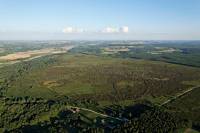
10LSL00316
Aerial photo of the agricultural landscape of the Vienna [AT]

10LSL00315
Aerial photo of Vienna Vouneuil [AT]
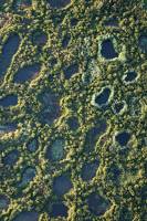
10LSL00314
Aerial photo of the natural reserve of Pinail [AT]
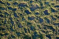
10LSL00313
Aerial photo of the natural reserve of Pinail [AT]
10LSL00312
Aerial photo of the natural reserve of Pinail [AT]